Zebulon Montgomery Pike


090202_16a_ZebulonMPike

Zebulon Montgomery Pike (January 5, 1779 – April 27, 1813) was an American brigadier general and explorer for whom Pikes Peak in Colorado is named. As a United States Army captain in 1806–1807, he led the Pike Expedition to explore and document the southern portion of the Louisiana territory and to find the headwaters of the Red River, during which he recorded the discovery of what later was called Pikes Peak. Captured by the Spanish while wandering in present-day Colorado after his party got confused in its travels, Pike and his men were taken to Chihuahua, present-day Mexico and questioned by the governor. They were released later in 1807 at the border of Louisiana.

In 1810 Pike published an account of his expeditions, a book so popular that it was translated into French, German and Dutch for publication in Europe. He later achieved the rank of brigadier general in the Army, serving during the War of 1812. He was killed during the Battle of York, which the United States won.

Early and Family Life

Early life and education

Zebulon M. Pike was born during the Revolutionary War on January 5, 1779 near Lamberton (derived from the Indian pronunciation “Alamatunk”), now called Lamington, in Somerset county, New Jersey. Pike would follow in the footsteps of his father, also named Zebulon, who had begun his own career in the military service of the United States beginning in 1775, at the outset of the American Revolutionary War. To avoid confusion, son Zebulon Pike is referred to with the middle initial of M, while father Zebulon Pike is not.

The younger Pike grew to adulthood with his family at a series of Midwestern outposts —the United States’ frontier at the time — in Ohio and Illinois. In 1799 he joined his father’s regiment as a cadet at the age of 20, earned a commission as ensign in 1804 and a first lieutenancy later that year.

Ancestry

Pike was descended from John Pike, who immigrated from England as a child in 1635, and helped found Woodbridge, New Jersey in 1665. A Surname DNA project exists for male individuals with the Pike surname. A genetic study of submitted DNA samples shows almost 20% have a genetic relationship to the same male line as Zebulon M. Pike, though he left no male descendants. This paternal line descends from a male ancestor of the seventeenth or eighteenth centuries, possibly John Pike.

Marriage and family

Zebulon M. Pike married Clarissa Harlow Brown in 1801. They had one child who survived to adulthood, a daughter, Clarissa Brown Pike, who later married John Cleves Symmes Harrison, a son of President William Henry Harrison.

Military career

Pike’s military career included working on logistics and payroll at a series of frontier posts, including Fort Bellefontaine near St. Louis. General James Wilkinson, appointed Governor of the Upper Louisiana Territory and headquartered there, became his mentor.

In 1805, Wilkinson ordered Pike to find the source of the Mississippi River, so Pike traveled into the northern Louisiana Territory, newly purchased from Spain. Over 100 years later, Spain released official records showing General Wilkinson received personal trade concessions and thus could be labeled a double agent for Spain at the time.

Pike Expedition

After Pike returned from this first expedition, General Wilkinson almost immediately ordered him to mount a second expedition, this time to explore, map and find the headwaters of the Arkansas and Red rivers. This exploratory expedition into the southwestern part of the Louisiana Territory was also to evaluate natural resources, and establish friendly relations with Native Americans.

Thus, beginning July 15, 1806, Pike led what became known as the “Pike Expedition”. General Wilkinson’s son served as one of his lieutenants, although it now seems that Wilkinson planned that the Spanish who controlled Mexico would capture him and his men.

In early November 1806, Pike and his team sighted and tried to climb to the summit of the peak later named after him (Pikes Peak.) They made it as far as Mt. Rosa to the southeast of Pikes Peak, before giving up the ascent in waist-deep snow. They had already gone almost two days without food.

They then continued south searching for the Red River’s headwaters, and built a fort for shelter during the winter. However, they had crossed the border, whether through confusion or deliberation. Spanish authorities captured Pike and some of his party in northern New Mexico (now part of southern Colorado) on February 26, 1807.

Pike and his men were taken to Santa Fe, then to the capital of Chihuahua province, and presented to Commandant General Salcedo, who was governor of the state. Pike was treated well and invited to formal social dinners, but still not quite given the treatment of a visiting dignitary, and his men were kept prisoner. Salcedo housed Pike with Juan Pedro Walker, a cartographer, who also acted as an interpreter. Walker transcribed and translated Pike’s confiscated documents, including his journal. Mexican authorities also feared the spread of both democracy and Protestant Christian sects that might undermine their rule.

During this time, Pike had access to various maps of the southwest and learned about Mexican discontent with Spanish rule. Spain filed official protests with the United States about Pike’s expedition, but since the nations were not at war (and Spain was rebelling against Napoleon’s brother who was fighting England in the Peninsular War), Commandant Salcedo released the military men. The Spanish escorted Pike and most of his men north, releasing them at the Louisiana border on July 1, 1807. However, some of his soldiers were held for years in Mexico. The Red River, which later separated Oklahoma Territory from Texas, was next explored by the ill-fated Woolley expedition of 1815, named for the Colonel who died (and only two sick men returned, one of whom soon died).

War of 1812

Pike was promoted to captain during the southwestern expedition. In 1811, Lt. Col. Zebulon M. Pike with the 4th Infantry Regiment fought at the Battle of Tippecanoe. He was promoted to colonel in 1812. Pike’s military career also included serving as deputy quartermaster-general in New Orleans and inspector-general during the War of 1812.

Pike was promoted to brigadier general in 1813. Along with General Jacob Brown, Pike departed from the newly fortified rural military outpost of Sackets Harbor, on the New York shore of Lake Ontario, for what became his last military campaign. On this expedition, Pike commanded combat troops in the successful attack on York, (now Toronto) on April 27, 1813. Pike was killed by flying rocks and other debris when the withdrawing British garrison blew up its ammunition magazine as Pike’s troops approached Fort York. His body was brought by ship back to Sackets Harbor, where his remains were buried at the military cemetery.

Journals

The Spanish authorities confiscated Pike’s journals; they were not recovered by the United States from Mexico until the 1900s. He wrote an account from memory of his expeditions, which was published in 1810 as The expeditions of Zebulon Montgomery Pike to Headwaters of the Mississippi River, through Louisiana Territory, and in New Spain, during the Years 1805-6-7. It was popular and later translated into French, German, and Dutch editions. His account became required reading for all American explorers who followed him in the 19th century.

His capture by the Spanish and travel through the Southwest gave Pike insight into the region. He described the politics in Chihuahua, which led to the Mexican independence movement. He also described trade conditions in the Spanish territories of New Mexico and Chihuahua, which contributed to development of the Santa Fe Trail.


René Caillié


caillie

René Caillié (19 November 1799 – 17 May 1838) was a French explorer and the first European to return alive from the town of Timbuktu.

Caillié was born in western France in a village near the port of Rochefort. His parents were poor and died while he was still young. At the age of 16 he left home and signed up as a member of the crew of a French naval vessel sailing to Saint-Louis in French West Africa. He stayed for several months and then crossed the Atlantic to Guadeloupe on a merchantman. He made a second visit to Africa two years later when he accompanied a British expedition across the Ferlo Desert to Bakel on the Senegal River.

Caillié returned to Saint-Louis in 1824 with a strong desire to become an explorer and visit Timbuktu. In order to avoid some of the difficulties experienced by the earlier expeditions, he planned to travel alone disguised as a Muslim. He persuaded the French governor in Saint-Louis to help finance a stay of 8 months with the nomadic people in the Brakna region of southern Mauritania where he learned Arabic and the customs of Islam. He failed to obtain further funding from either the French or the British governments, but encouraged by the prize of 10,000 francs offered by the Société de Géographie in Paris for the first person to return with a description of Timbuktu, he decided to fund the journey himself. He worked for a few months in the British colony of Sierra Leone to save some money, then travelled by ship to Boké on the Rio Nuñez in modern Guinea. From there in April 1827 he set off across West Africa. He arrived in Timbuktu a year later and stayed there for two weeks before heading across the Sahara Desert to Tangier in Morocco.

On his return to France, he was awarded the prize of 10,000 francs by the Société de Géographie and helped by the scholar Edme-François Jomard, published an account of his journey. Caillié married and settled near his birthplace. He suffered from poor health and died of tuberculosis aged 38.

Early life and first trip to Africa

René Caillié was born on 19 November 1799 in Mauzé-sur-le-Mignon, a village in the department of Deux-Sèvres in western France. His father, François Caillé, had worked as a baker but four months before René was born he was accused of petty theft and sentenced to 12 years of hard labour in a penal colony at Rochefort. He died there in 1808 at the age of 46. René’s mother, Élizabeth née Lépine, died three years later in 1811 at the age of 38. After her death, René and his 18 year old sister, Céleste, were cared for by their maternal grandmother.

In the introduction to his Travels through Central Africa to Timbuctoo Caillié described how as a teenager he had been fascinated by books on travel and exploration:

… and as soon as I could read and write, I was put to learn a trade, to which I soon took a dislike, owing to the reading of voyages and travels, which occupied all my leisure moments. The History of Robinson Crusoe, in particular, inflamed my young imagination : I was impatient to encounter adventures like him; nay, I already felt an ambition to signalize myself by some important discovery springing up in my heart.

Caillié left home at the age of 16 with 60 francs that he had inherited from his grandmother. He made his way to the port of Rochefort, 50 km from Mauzé-sur-le-Mignon on the River Charente. There he signed up as a crew member on the Loire, a French naval storeship that was to accompany the frigate Méduse and two other vessels on a voyage to reclaim the French colony of Saint-Louis from the British under the terms of the 1814 and 1815 Paris Treaties. The four ships left their anchorage near the Île d’Aix at the mouth of the Charente River in June 1816. The Méduse went ahead of the Loire and was wrecked on the Bank of Arguin off the coast of present day Mauritania. A few survivors were picked up by the other vessels. The shipwreck received a large amount of publicity and was the subject of a famous oil painting, The Raft of the Medusa, by Théodore Géricault. When the three remaining French ships arrived at Saint-Louis they found that British governor was not ready to hand over the colony and therefore continued southwards and moored off the island of Gorée near Dakar. Caillié spent some months in Dakar, which was then only a village, before returning by ship to Saint-Louis. There he learned that an English expedition led by Major William Gray was preparing to leave from the Gambia to explore the interior of the continent. Caillié wished to offer his services and set off along the coast with two companions. He intended to cover the 300 km on foot but found the oppressive heat and lack of water exhausting. He abandoned his plan at Dakar and instead obtained a free passage on a merchantman across the Atlantic to Guadeloupe.

Caillié found employment for six months in Guadeloupe. While there he read Mungo Park’s account of his exploration of the Middle Niger in present day Mali. Park had been the first European to reach the Niger River and visit the towns of Ségou, Sansanding and Bamako. An account of his first trip had been published in French in 1799. Park made a second expedition beginning in 1805 but was drowned in descending the rapids on the Niger near Bussa in present day Nigeria. An account of the second trip had been published in English in 1815.

Caillié returned to Bordeaux in France and then travelled to Senegal where he arrived at end of 1818. He made a journey to Bundu to carry supplies to a British expedition then in that country. Ill with fever he was obliged to go back to France, but in 1824 was again in Senegal with the idea of reaching Timbuktu. The Paris based Société de Géographie was offering a 10,000 franc reward to the first European to see and return alive from Timbuktu, believed to be a rich and wondrous city.

He spent eight months with the Brakna Moors living north of the Senegal River, learning Arabic and being taught, as a convert, the laws and customs of Islam. He laid his project of reaching Timbuktu before the governor of Senegal, but receiving no encouragement went to Sierra Leone where the British authorities made him superintendent of an indigo plantation. Having saved £80 he joined a Mandingo caravan going inland. He was dressed as a Muslim, and gave out that he was an Arab from Egypt who had been carried off by the French to Senegal and was desirous of regaining his own country.

Timbuktu

Starting from Kakondy near Boké on the Rio Nuñez on April 19, 1827, Caillié travelled east along the hills of Fouta Djallon, passing the head streams of the Senegal and crossing the Upper Niger at Kurussa. Still going east he came to the Kong highlands, where at the village of Tiémé in present day Ivory Coast, he was detained for five months (3 August 1827 to 9 January 1828) by illness. Resuming his journey in January 1828 he went north-east and reached the city of Djenné where he stayed from 11 to the 23 March. From Djenné he continued his journey to Timbuktu by boat. After spending a fortnight (April 20 – May 4) in Timbuktu he joined a caravan crossing the Sahara to Morocco, reaching Fez on the August 12. From Tangier he returned to France.

Caillié was preceded at Timbuktu by a British officer, Major Gordon Laing, but Laing had been murdered in September 1826 on leaving the city and Caillié was the first to return alive. He was awarded the prize of 10,000 francs offered by the Société de Géographie to the first traveller who should gain exact information of Timbuktu, to be compared with that given by Mungo Park. He also received the order of the Legion of Honor, a pension, and other distinctions, and it was at the public expense that his Journal d’un voyage à Temboctou et à Jenné dans l’Afrique Centrale, etc. (edited by Edme-François Jomard) was published in three volumes in 1830.

Caillié died of tuberculosis on May 17, 1838, at La Gripperie-Saint-Symphorien, in the department of Charente-Maritime where he owned the manor L’Abadaire.

Caillié is remarkable for his approach to exploration. In a period given to large-scale expeditions supported by soldiers and employing black porters, Caillié spent years learning Arabic, studying the customs and Islamic religion before setting off with a companion, and later on his own, traveling and living as the natives did. He also did not romanticize his discoveries to increase his fame, unlike Laing who recorded that Timbuktu was a wondrous city, Caillié told the truth: it was a small, unimportant, and poor village with no hint of the fabled reputation that preceded it.


Dominion of Newfoundland


600px-Dominion_of_Newfoundland_Red_Ensign.svg

The Dominion of Newfoundland was a British Dominion from 1907 to 1949 (before which the territory had the status of a British colony, self-governing from 1855). The Dominion of Newfoundland was situated in northeastern North America along the Atlantic coast and comprised the island of Newfoundland and Labrador on the continental mainland. The Statute of Westminster of 11 December 1931 provided a mechanism for Newfoundland to achieve independence within the British Commonwealth, but rather than ratify it, after the near bankruptcy in 1933, on 16 February 1934 the Newfoundland Parliament passed an Address to the Crown relinquishing self-government. Responsible government in Newfoundland voluntarily ended and governance of the dominion reverted to direct control from London — one of the few countries that has ever voluntarily given up direct self-rule. Between 1934 and 1949 a six-member Commission of Government (plus a governor) administered Newfoundland, reporting to the Dominions Office in London. Newfoundland remained a de jure dominion until it joined Canada in 1949 to become Canada’s tenth province.
The Union Flag was adopted by the legislature as the official national flag of the Dominion of Newfoundland on 15 May 1931, before which time the Newfoundland Red Ensign, as civil ensign of Newfoundland, was used as the national flag (though not officially adopted by the legislature).
Political origins
In 1854 the British government established Newfoundland’s responsible government. In 1855, Philip Francis Little, a native of Prince Edward Island, won a parliamentary majority over Sir Hugh Hoyles and the Conservatives. Little formed the first administration from 1855 to 1858. Newfoundland rejected confederation with Canada in the 1869 general election. Prime Minister of Canada Sir John Thompson came very close to negotiating Newfoundland’s entry into confederation in 1892.
It remained a colony until acquiring dominion status in 1907 after the 1907 Imperial Conference decided to confer dominion status on all self-governing colonies.
First World War and after
Newfoundland’s own regiment, the 1st Newfoundland Regiment, fought in the First World War. On 1 July 1916, the German Army wiped out most of that regiment at Beaumont Hamel on the first day on the Somme, inflicting 90 percent casualties. Yet the regiment went on to serve with distinction in several subsequent battles, earning the prefix “Royal”. Despite people’s pride in the accomplishments of the regiment, Newfoundland’s war debt for the regiment and the cost of maintaining a trans-island railway led to increased and ultimately unsustainable government debt in the post-war era.
After the war, Newfoundland along with the other dominions sent a separate delegation to the Paris Peace Conference but, unlike the other dominions, Newfoundland did not sign the Treaty of Versailles in her own right, nor did she seek a separate membership in the League of Nations.
In the 1920s, political scandals wracked the dominion. In 1923, the attorney general arrested Newfoundland’s prime minister Sir Richard Squires on charges of corruption. Despite his release soon after on bail, the British-led Hollis Walker commission reviewed the scandal. Soon after, the Squires government fell. Squires returned to power in 1928 because of the unpopularity of his successors, the pro-business Walter Stanley Monroe and (briefly) Frederick C. Alderdice (Monroe’s cousin), but found himself governing a country suffering from the Great Depression.
The Judicial Committee of the Imperial Privy Council resolved Newfoundland’s long-standing Labrador boundary dispute with Canada to the satisfaction of Newfoundland and against Canada (and, in particular, contrary to the wishes of Quebec, the province that bordered Labrador) with a ruling on 1 April 1927. Prior to 1867, the Quebec North Shore portion of the “Labrador coast” had shuttled back and forth between the colonies of Lower Canada and Newfoundland. Maps up to 1927 showed the coastal region as part of Newfoundland, with an undefined boundary. The Privy Council ruling established a boundary along the drainage divide separating waters that flowed through the territory to the Labrador coast, although following two straight lines from the Romaine River along the 52nd parallel, then south near 57 degrees west longitude to the Gulf of Saint Lawrence. Quebec has long rejected the outcome, and Quebec’s provincially issued maps do not mark the boundary in the same way as boundaries with Ontario and New Brunswick.
End of responsible government
As a small country which relied primarily upon the export of fish, paper and minerals, the Great Depression hit Newfoundland very hard. Economic frustration combined with anger over government corruption led to a general dissatisfaction with democratic government. On 5 April 1932, a mob of 10,000 people marched on the Colonial Building (seat of the House of Assembly) and forced prime minister Squires to flee. Squires lost the election held later in 1932. The next government, led once more by Alderdice, called upon the British government to take direct control until Newfoundland could become self-sustaining. The United Kingdom, concerned over Newfoundland’s likelihood of defaulting on its war-debt payments, established the Newfoundland Royal Commission, headed by a Scottish peer, William Mackenzie, 1st Baron Amulree. Its report, released in 1933, assessed Newfoundland’s political culture as intrinsically corrupt and its economic prospects as bleak, and advocated the abolition of responsible government and its replacement by a Commission of the British Government. Acting on the report’s recommendations, Alderdice’s government voted itself out of existence in December 1933.
In 1934, the Dominion suspended Newfoundland’s self-governing status and the Commission of Government took control. Newfoundland remained a dominion in name only. A severe depression persisted until the Second World War broke out in 1939.
Second World War
Given Newfoundland’s strategic location in the Battle of the Atlantic, the Allies (especially the United States of America) built many military bases there. Large numbers of unskilled men gained the first paycheques they had seen in years by working on construction and in dockside crews. National income doubled overnight as an economic boom took place in the Avalon Peninsula and to a lesser degree in Gander, Botwood, and Stephenville. The United States became the main supplier, and American money and influence diffused rapidly from the military, naval, and air bases. Prosperity returned to the fishing industry by 1943. Government revenues, aided by inflation and new income, quadrupled, even though Newfoundland had tax rates much lower than those in Canada, Britain, or the United States. To the astonishment of all, Newfoundland started financing loans to London. Wartime prosperity ended the long depression and reopened the question of political status.
The American Bases Act became law in Newfoundland on 11 June 1941. Newfoundland girls married American personnel by the thousands, “the Yanks’ jaunty manner and easy social ways making an often stark contrast to the Canadian servicemen who at this time began to coin the epithet ‘Newfie.'” (So many Newfoundland war brides moved to the United States that the government designed a postwar tourism campaign specifically for this audience.) The American connection worked so well that the Canadian government in Ottawa became alarmed. A new political party formed in Newfoundland to support closer ties with the U.S., the Economic Union Party, which Earle characterises as “a short-lived but lively movement for economic union with the United States”. Advocates of union with Canada denounced the Economic Union Party as republican, disloyal and anti-British; Britain refused to allow the voting populace the option to choose union with the U.S., and the U.S. State Department, needing British and Canadian cooperation during the Second World War, decided not to interfere.
National Convention and referenda
Following the Second World War, in 1946, an election took place to determine the membership of the Newfoundland National Convention, charged with deciding the future of Newfoundland. The Convention voted to hold a referendum to decide between continuing the Commission of Government or restoring responsible government. Joseph R. Smallwood, the leader of the confederates, moved for the inclusion of a third option — that of confederation with Canada. The Convention defeated his motion, but he did not give up, instead gathering more than 5,000 petition signatures within a fortnight, which he sent to London through the governor. The United Kingdom, insisting that it would not give Newfoundland any further financial assistance, added this third option of having Newfoundland join Canada to the ballot. After much debate, an initial referendum took place on 3 June 1948, to decide between continuing with the Commission of Government, reverting to dominion status, or joining the Canadian Confederation. Three parties participated in the referendum campaign: Smallwood’s Confederate Association campaigned for the confederation option while in the anti-confederation campaign Peter Cashin’s Responsible Government League and Chesley Crosbie’s Economic Union Party (both of which called for a vote for responsible government) took part. No party advocated petitioning Britain to continue the Commission of Government.
The result proved inconclusive, with 44.5 percent supporting the restoration of dominion status, 41.1 percent for confederation with Canada, and 14.3 percent for continuing the Commission of Government. Between the first and second referendums, rumour had it that Catholic bishops were using their religious influence to alter the outcome of the votes. The Orange Order, incensed, called on all its members to vote for confederation, as the Catholics voted for responsible government. The Protestants of Newfoundland outnumbered the Catholics by a ratio of 2:1. Some commentators believe that this sectarian divide influenced the outcome of the second referendum, on 22 July 1948, which asked Newfoundlanders to choose between confederation and dominion status, produced a vote of 52 percent to 48 percent for confederation, and Newfoundland joined Canada on 31 March 1949.
Not everyone accepted the results, however. Peter John Cashin, an outspoken anti-Confederate, questioned the validity of the votes. He claimed that an “unholy union between London and Ottawa” brought about confederation.
National anthem
The official anthem of the Dominion of Newfoundland was the “Ode to Newfoundland”, written by British colonial governor Sir Charles Cavendish Boyle in 1902 during his administration of Newfoundland (1901 to 1904). It was adopted as the official anthem on 20 May 1904, until confederation with Canada in 1949. In 1980, the province of Newfoundland re-adopted the song as an official provincial anthem, making Newfoundland and Labrador the only province in Canada to adopt a provincial anthem officially. The “Ode to Newfoundland” continues to be heard at public events in the province to this day; however, only the first and last verses are traditionally sung.


Welland Canal


Map_of_the_Welland_Canal

The Welland Canal has gone through many incarnations in its history. Today, five distinct canal-construction efforts are recognized. The retronym First Welland Canal is applied to the original canal, constructed from 1824 to 1829 and 1831 to 1833.

Pre-canal times

The Great Lakes form an excellent navigation route into the interior of North America. Downstream from Niagara Falls, ships can reach the port city of Montreal without encountering major difficulties. Upstream, the lakes are navigable all the way to the western end of Lake Superior. Early on during the European settlement of North America, lack of other infrastructure made the Great Lakes the premier route to reach the interior of the continent, and later to ship materials and goods from the new frontiers.

The Niagara Falls stood as a mighty barrier. To bypass it, a portage road between Queenston, Ontario and Chippawa was used, but the solution was far from optimal. The cargo had to be unloaded, carried 18 km up the Niagara Escarpment, then loaded onto different ships to continue on its way.

The relatively narrow Niagara Peninsula, situated between Lake Ontario and Lake Erie, was a natural match to the idea of bypassing the Falls. Indeed, the idea of a canal across the Peninsula was examined as early as 1799, when a group headed by Robert Hamilton, a Queenston merchant, unsuccessfully petitioned the Legislative Assembly of Upper Canada. Hamilton’s plan called for a canal to be constructed between Fort Erie and, perhaps unsurprisingly, Queenston.

In 1816, a young man called William Hamilton Merritt bought a rundown sawmill on the Twelve Mile Creek, and added a grist mill and a store. The Twelve flowed from its source south of the Escarpment to Lake Ontario, but its water levels varied considerably, creating difficulties for Merritt and his mills. In 1818, when the flow was especially low, Merritt pursued the idea of bringing water to his mills from the Welland River.

On a bigger scale, the Erie Canal, dug from the Hudson River through northern New York, was about to reach Lake Erie. The impending completion meant the cargo from upper Great Lakes was about to head down the canal and Hudson River to New York City, bypassing its previous destination, Montreal. At the time, a considerable rivalry existed between Montreal and New York for cargo headed to Europe via ocean-going vessels. All of these factors contributed to the construction of the Welland Canal.

Planning

In 1818, William Hamilton Merritt borrowed an instrument called a water level from Samuel Beckett, a mill owner in St. Johns. Along with George Keefer, John DeCew, and a couple of other neighbours he set out to survey a potential route for a water canal. From the headwaters of the Twelve Mile Creek near present-day Allanburg, they planned a line three kilometers south to meet with the Welland River. A ridge was encountered along the way, and using the instrument, the surveyors calculated it to be 10 meters high. It was actually double that height; the reason for the error is not known.

On July 4, 1818, Merritt organized a meeting in St. Catharines. The outcome was a petition sent to Upper Canada Legislature to provide for construction of a canal between the Twelve Mile Creek and Welland River. Unlike Merritt’s original water-canal plan, the petition included plans for allowing boats to cross the Niagara Escarpment. In 1823, Hiram Tibbetts, an engineer, was employed to make a formal survey for the route. He suggested to dig a channel four feet below the surface level of Welland River between present-day Port Robinson and Allanburg, and then follow the Twelve Mile Creek northwest to DeCew’s Falls (where George DeCew owned a mill). There, it was suggested to descend the escarpment by an incline railway and continue along the creek to Port Dalhousie to reach Lake Ontario.

On January 19, 1824, an act of the Legislature formed the Welland Canal Company, with a capitalization of $150,000 and Merritt as the financial agent. As part of his fundraising duties, he travelled extensively, including the United States and Great Britain.

Later in 1824, a revised route was put forward for the canal. It travelled from Port Robinson to Allanburg like the previous one, but from there went north and descended the escarpment by a series of canal locks in present-day Merritton. The canal then followed a local creek before joining the Twelve Mile and continuing on to Port Dalhousie. (With this new route, John Decew, one of the original canal proponents would become an opponent, when he realised that the new route would not only bypass his property, but divert water from his mill.)

Construction

On November 30, 1824, approximately 200 people gathered near Allanburg to witness the sod-turning for the construction. Soon, contracts for the work were let out, but the actual construction didn’t start until July 1825. Wherever possible, natural waterways were used, but this was not possible for the construction of the canal between Port Robinson and Allanburg. In what was called the Deep Cut, a channel over three kilometers long was cut, sometimes as deep as 20 meters. No less than 750,000 cubic meters of earth was removed.

Prior to the construction of the Welland Canal, the main settlements in the area were located along Lake Ontario and Niagara River, as the interior of the Niagara Peninsula remained hard to reach and rural areas, if that. As the construction progressed, however, shantytowns to house the labourers and their families were established along the way, giving birth to communities that later became Port Dalhousie, Merritton, Thorold, Allanburg and Port Robinson.

As the Deep Cut progressed, plans were being made for an alternate route to Lake Erie. The original motivation behind the canal was to bring water to mills, and this was met by constructing a canal to the Welland River. However, as the plans evolved to include a ship route, they were accommodated by simply following the Welland River until it emptied into the Niagara River. This was suboptimal for a number of reasons, the main one being the strong current of Niagara and the proximity of the towering Niagara Falls that made the journey hard and uncomfortable. Due to this, a second route was planned to diverge from the canal at Port Robinson. It would follow the Welland River southwest, then branch off, following Forks Creek and a 20 kilometre channel cut through present-day Wainfleet and the Wainfleet Marsh to reach Grand River and Lake Erie.

In September 1827, work on the Deep Cut was paused due to heavy rains. Many workers were transferred to construction of the canal in Wainfleet, and have made significant progress before Deep Cut work was resumed the following April.

However, the rains continued. On November 9, 1828, just two weeks’ worth of work before completion of the Deep Cut, the banks of the cut near Port Robinson collapsed into the excavated channel, killing an unknown number of workers below. More landslides followed, and it soon became evident that making a cut deep enough as to use the Welland River as the source of canal water would not be possible. An alternate, sufficiently high source of water was necessary.

Feeder Canal

Since the construction of a channel towards Grand River was already underway at the time of the Deep Cut failure, a dam across the mouth of the Grand was proposed soon after, in December 1828. From there, a channel could be dug to feed this level to the Welland Canal proper. An aqueduct would be used to cross the Welland River.

The dam was relocated eight kilometers inland by naval authorities, mindful of its safety in times not long after the War of 1812. The settlement by the dam later evolved into present-day Dunnville. From there, the Feeder went southeast to Stromness, before turning northeast in a straight cut across the Wainfleet Marsh. Interestingly, the location chosen for the aqueduct across Welland River was not Port Robinson. Although the Welland Canal and River first met in Port Robinson, it was decided to dig the canal essentially parallel to the river for a couple of kilometers upstream before crossing it. The aqueducts of three subsequent canals were later built in the same spot.

Once again, many of the Deep Cut labourers were transferred to the Feeder cut. The digging was finished in the span of 177 days, which was a large achievement at the time. Lake Erie water was let into the Feeder and Welland Canals in November 1829.

As with other locations in the peninsula, shantytowns sprung up along the Feeder Canal. These later developed into places like Dunnville, Wainfleet and Welland, among others.

The Welland Canal was officially opened on November 30, 1829, exactly five years after the first turning of the sod. Two schooners, Annie and Jane from York, Upper Canada and R.H. Broughton from Youngstown, New York, left Port Dalhousie on Lake Ontario and arrived in Buffalo on the eastern end of Lake Erie two days later. Annie and Jane returned to Lake Ontario along the same route four days later.

On to Lake Erie

As mentioned before, the route to Lake Erie afforded by the canal, following the Welland and Niagara Rivers, was difficult and slow. The Feeder connected directly to Lake Erie, but it was long, and, not intended as a ship canal, of insufficient capacity. Over the course of the canal’s first full navigation season in 1830, it became evident that a more direct route was necessary.

In March 1831, a location called Gravelly Bay (now Port Colborne) was chosen as the new Lake Erie terminus for the canal. It was one of the closest points on the Lake Erie shore, and also offered a natural harbour for the ships waiting to enter the canal. The new part of the canal was to run in a fairly straight line, except for a stretch where it followed a local ravine and a creek to minimise required excavation of hard rock in the area.

The Welland Canal Company obtained a loan of 50,000 pounds from the Province of Upper Canada. Construction started soon after, but it was delayed by rain, difficulty in clearing land, and a cholera outbreak in 1832. Neither the Wainfleet Marsh nor the rock south of it were easy to dig in, but work was accelerated during mild weather of late 1832 and early 1833.

On June 1, 1833, the schooner Matilda, headed for Cleveland from Oakville, became the first ship to travel through the new channel.

Completion

Overall, the combined Welland and Feeder Canals stretched 44 kilometres (27 mi) between the two lakes, with 40 wooden locks. The minimum lock size was 33.5 m by 6.7 m (110 ft by 22 ft), with a minimum canal depth of 2.4 m (8 ft).

Today, very little of the First Canal is evident. Much of the Feeder Canal, however is still present today in Wainfleet township.


Province of Massachusetts Bay


250px-Masscolony

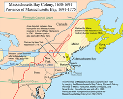
The Province of Massachusetts Bay was a crown colony in North America and one of the thirteen original states of the United States. It was chartered on October 7, 1691 by William and Mary, the joint monarchs of the kingdoms of England, Scotland and Ireland. The charter took effect on May 14, 1692 and included the Massachusetts Bay Colony, the Plymouth Colony, the Province of Maine, Martha’s Vineyard, Nantucket, Nova Scotia and New Brunswick. The modern Commonwealth of Massachusetts is the direct successor; Maine is an independent state, and Nova Scotia and New Brunswick are Canadian provinces.

The name Massachusetts comes from the Massachusett, an Algonquian tribe. The name has been translated as “at the great hill”, “at the place of large hills”, or “at the range of hills”, with reference to the Blue Hills, and in particular, Great Blue Hill.

Background

Colonial settlement of the shores of Massachusetts Bay began in 1620 with the founding of the Plymouth Colony. Other attempts at colonization took place throughout the 1620s, but expansion of English settlements only began on a large scale with the founding of the Massachusetts Bay Colony in 1628 and the arrival of the first large group of Puritan settlers in 1630 Over the next ten years there was a major migration of Puritans to the area, leading to the founding of a number of new colonies in New England. By the 1680s the number of colonies had stabilized at five: in addition to Massachusetts Bay and Plymouth, Connecticut, Rhode Island and New Hampshire all bordered the area. Massachusetts Bay was the most populous and economically significant, housing a sizable merchant fleet.

The colonies at times struggled against the local Indian population, which had suffered a serious decline in population (most likely at the hands of infectious diseases brought over by European traders and fishermen) prior to the arrival of the first permanent settlers. In the 1630s the Pequot tribe was virtually destroyed, and King Philip’s War in the 1670s resulted in the expulsion, pacification, or killing of most of the Indians in southern New England. The latter war was also costly to the colonists of New England, putting a halt to expansion for several years.

Massachusetts and Plymouth were both somewhat politically independent from England in their early days, but this situation changed after the restoration of Charles II to the English throne in 1660. Charles sought closer oversight of the colonies, and to introduce and enforce economic control over their activities. The Navigation Acts passed in the 1660s were widely disliked in Massachusetts, where merchants often found themselves trapped and at odds with the rules. However, many colonial governments, Massachusetts principally among them, refused to enforce the acts themselves, and took matters one step further by obstructing the activities of the Crown agents themselves. The religiously conservative Puritan rulers of Massachusetts also refused to tolerate the Church of England, and yet at the same time were intolerant of other religious groups, banishing Baptists and executing Quakers who defied their banishment. These issues and others led to the revocation of the first Massachusetts Charter in 1684.

In 1686 Charles II’s successor, King James II, formed the Dominion of New England, which ultimately joined all of the British territories from Delaware Bay to Penobscot Bay into a single political unit. The Dominion’s governor, Sir Edmund Andros, was highly unpopular in the colonies, but was especially hated in Massachusetts, where he angered virtually everyone by enforcing of the Navigation Acts, vacating land titles, appropriating a Puritan meeting house as a site to host services for the Church of England, and his restriction of town meetings, among other sundry complaints. When James was deposed in the 1688 Glorious Revolution, Massachusetts political leaders conspired against Andros, arresting him and other English authorities in April 1689.This led to the collapse of the Dominion, as the other colonies then quickly reasserted their old forms of government.

The Plymouth colony had never had a royal charter, so its governance had always been on a somewhat precarious footing. Massachusetts, however, was placed into constitutional anarchy by the uprising. Although the colonial government was reestablished, it no longer had a valid charter, as a result of which some opponents of the old Puritan rule refused to pay taxes, and engaged in other forms of protest. Provincial agents traveled to London where Increase Mather, representing the old colony leaders, petitioned new rulers William and Mary to restore the old colonial charter. When King William learned that this might result in a return to the predominantly entrenched religious rule, he refused. Instead, the Lords of Trade decided to solve two problems at once by combining the two colonies. Accordingly on October 7, 1691, they issued a charter for the Province of Massachusetts Bay, and appointed Sir William Phips its governor.

Provincial charter

The new charter differed from the old one in several important ways: one of the principal changes, inaugurated over Mather’s objection, was to change the test requirements for attaining voting eligibility from religious to financial. Although the effect of this change has been subject to debate among historians, there is significant consensus that it greatly enlarged the number of men eligible to vote. The new rules required prospective voters to own £40 worth of property, or real estate that yielded at least £2 per year in rent, and has been estimated to have thus included three quarters of the then adult male population as eligible.

The second major change was that senior officials of the government, including governor, lieutenant governor, and judges, were appointed by the crown instead of being elected. The legislative assembly, or General Court, continued to be elected, however, and was responsible for choosing members of the Governor’s Council. The governor had veto power over laws passed by the General Court, as well as over appointments to the council. These rules differed in important ways from the royal charters enjoyed by other provinces. The most important were that the General Court now possessed the powers of appropriation, and that the council was locally chosen and not appointed by either the governor or the Crown. These significantly weakened the governor’s power, something that came to be of importance later in provincial history.

A third reason for the changes may have been to reduce the deadly influence of religious superstition in the colony, as evidenced by the Salem Witch Trials, which also occurred in 1692.

The province’s territory was also greatly expanded beyond that originally claimed by the predecessor Massachusetts and Plymouth colonies. In addition to their territories, which included present-day mainland Massachusetts, western Maine, and portions of all of the neighboring modern states, the territory was expanded to include Acadia or Nova Scotia (then encompassing modern Nova Scotia, New Brunswick, and eastern Maine), as well as what was then known as Dukes County in the Province of New York, consisting of the islands of Nantucket, Martha’s Vineyard, and the Elizabeth Islands.

History

The early years of the province were dominated by the Salem witch trials and by King William’s War (1689–97). In the aftermath of the revolt against Andros, colonial defenses had been withdrawn from the frontiers, which then repeatedly were raided by French and Indian forces from Canada and Acadia. War again broke out in 1702 with Queen Anne’s War, which lasted until 1713. Massachusetts Governor Joseph Dudley organized the colonial defenses, and there were fewer raids than in the earlier war. Dudley also organized expeditions against Acadia, a haven for French privateers, in 1704 and 1707, and requested support from London for more ambitious efforts against New France. In 1709 Massachusetts raised troops for an expedition against Canada that was called off, and again in 1710, when Port Royal, the Acadian capital, was finally captured.

Because of the wars, the colony had issued paper currency, whose value was constantly in decline, leading to financial crises. This led to proposals to create a bank that would issue notes backed by real estate, but this move was opposed by Governor Dudley and his successor, Samuel Shute. Dudley and Shute, as well as later governors, engaged in fruitless attempts to convince the general court to fix salaries for crown-appointed officials. The issues of currency and salary were both long-lived issues over which governors and colonists fought. The conflict over salary reached a peak of sorts during the short-lived administration of William Burnet. He held the provincial assembly in session for six months, relocating it twice, in an unsuccessful attempt to force the issue.

In the early 1720s the Abenaki of northern New England, encouraged by French intriguers but also concerned over British encroachment on their lands, resumed raiding of frontier communities. This violence was eventually put down by Acting Governor William Dummer, leading the conflict to be called Dummer’s War (among many other names). Many Abenakis retreated from northern New England into Canada after the conflict.

In the 1730s Governor Jonathan Belcher, a native son, disputed the power of the legislature to direct appropriations, vetoing bills that did not give him the freedom to disburse funds as he saw fit. This meant that the provincial treasury was often empty. Belcher was, however, permitted by the Board of Trade to accept annual grants from the legislature in lieu of a fixed salary. Under his administration the currency crisis flared again. This resulted in a revival of the land bank proposal, which Belcher opposed. His political opponents intrigued in London to have him removed, and the bank was established. Its existence was short-lived, for an act of Parliament forcibly dissolved it. This turned a number of important colonists (including the father of American Revolutionary War political leader Samuel Adams) against crown and Parliament.

The next twenty years were dominated by war. King George’s War broke out in 1741, and Governor William Shirley rallied troops from around New England for an assault on the French fortress at Louisbourg. which succeeded in 1745. However, much to the annoyance of New Englanders, Louisbourg was returned to France at the end of the war in 1748. Governor Shirley was relatively popular, in part because he managed to avoid or finesse the more contentious issues his predecessors had raised. He was again militarily active when the French and Indian War broke out in 1754. Raised to the highest colonial military command by the death of General Edward Braddock in 1755, he was unable to manage the large-scale logistics the war demanded, and was recalled in 1757. His successor, Thomas Pownall, oversaw the colonial contribution to the remainder of the war, which ended in North America in 1760.

The 1760s and early 1770s were marked by a rising tide of colonial frustration with London’s colonial policies, and with the governors sent to implement and enforce them. Both Francis Bernard and Thomas Hutchinson, the last two non-military governors, were widely disliked over issues large and small, notably the Parliament’s attempts to impose taxes on the colonies without representation. Hutchinson, a Massachusetts native who served for many years as lieutenant governor, authorized the quartering of British Army troops in Boston, which eventually precipitated the Boston Massacre on March 5, 1770. By this time, agitators like Samuel Adams, Paul Revere, and John Hancock were active in opposition to crown policies. After the Boston Tea Party in December 1773, Hutchinson was replaced in May 1774 by General Thomas Gage. Gage was at first well-received, but the reception rapidly became worse as he began to implement the so-called Intolerable Acts, including the Massachusetts Government Act, which dissolved the legislature, and the Boston Port Act, which closed the port of Boston until reparations were paid for the dumped tea. The port closure did great damage to the provincial economy, and led to a wave of sympathetic assistance from other colonies.

The royal government of the Province of Massachusetts Bay existed de facto until early October 1774, when members of the General Court of Massachusetts met in contravention of the Massachusetts Government Act and established the Massachusetts Provincial Congress. Although Governor Gage continued an essentially military rule in Boston, the provincial congress had effective rule in the rest of the province. Hostilities starting the American Revolutionary War broke out in April 1775 at Lexington and Concord, which continued with the Siege of Boston. The British evacuated Boston on March 17, 1776, ending the siege and bringing the city under rebel control. On May 1, 1776 the provincial congress adopted a resolution declaring the province to be independent of the crown; this was followed up by the United States Declaration of Independence on July 4, 1776 declaring the independence of all of the Thirteen Colonies.

The Constitution of the Commonwealth of Massachusetts was agreed upon in Cambridge in October 1779 and adopted by the delegates nine months later in June 1780, to go into effect “the last Wednesday of October next”. In elections held in October 1780, John Hancock was elected the first Governor of Massachusetts along with representatives to the commonwealth’s first General Court.

Politics

Provincial politics

According to Thomas Hutchinson, who wrote the first major history of colonial Massachusetts, the politics of the province was dominated by three major factions. This is in distinction to most of the other colonies, where there were two factions. Expansionists, exemplified in Massachusetts by people like Thomas Hancock, uncle to John Hancock, and James Otis, Sr., believed strongly in the growth of the colony and a vigorous defense against French and Indian incursions. This faction became a vital force in the Patriot movements preceding the revolution. Nonexpansionists, exemplified by Hutchinson and the Oliver family of Boston, were more circumspect, preferring to rely on a strong relationship with the mother country. This faction would become Loyalist in the revolutionary era. The third force in Massachusetts politics was a populist faction made possible by the structure of the provincial legislature, in which rural and lower class communities held a larger number of votes than in other provinces. Its early leaders included the Cookes (Elisha senior and junior) of Maine, while later leaders included revolutionary firebrand Samuel Adams. Although religion did not play a major role in these divisions, nonexpansionists tended to be Anglican, while expansionists were mainly middle-of-the road Congregationalist. Populists generally held either conservative Puritan views or the revivalist views of the First Great Awakening. Throughout the provincial history, these factions made and broke alliances as conditions and circumstances dictated.

The populist faction had concerns that sometimes prompted it to support one of the other parties. Its rural character meant that when there were troubles on the frontier, they sided with the expansionists. They also tended to side with the expansionists on the recurring problems with the local money, whose inflation tended to favor their ability to repay debts in depreciated currency. These ties became stronger in the 1760s as the conflict with Parliament grew.

The nonexpansionists were composed principally of a wealthy merchant class in Boston. They had allies in the wealthy farming communities in the more developed eastern portions of the province, and in the province’s major ports. This alliance often rivalled the populist party in power in the provincial legislature. It favored stronger regulation from the mother country, and opposed the inflationist issuance of colonial currency.

Expansionists mainly came from two disparate groups. The first was a portion of the eastern merchant class, represented by the Hancocks and Otises, who harbored views of the growth of the colony and held relatively liberal religious views. They were joined by wealthy landowners in the Connecticut River valley, whose needs for defense and growth were directly tied to property development. Although these two groups agreed on defense and an expansionist vision, they disagreed on the currency issue, with the westerners siding with the nonexpansionists in their desire for a standards-based currency.

Local politics

The province significantly expanded its geographic reach, principally in the 18th century. In 1695 there were 83 towns, which grew to 186 in 1765. Most of the towns in 1695 were within one days’ travel of Boston, but this changed as townships sprang up in Worcester County and the Berkshires on land that had been under Indian control prior to King Philip’s War.

The character of local politics changed as the province prospered and grew. Unity of community during the earlier colonial period gave way to subdivision of larger towns. Dedham, for example, was split into six towns, and Newburyport was separated from Newbury in 1764.

Town meetings also became more important in local political life. As towns grew, the townspeople became more assertive in managing their affairs, and the town selectmen, who had previously wielded significant power, lost some of their influence to the town meetings and to the appointment of paid town employees, such as tax assessors, constables, and treasurers.

Geography

The boundaries of the province changed in both major and minor ways during its existence. Nova Scotia, then including New Brunswick, was occupied by English forces at the time of the charter’s issuance, but was separated in 1697 when the territory, called Acadia by the French, was formally returned to France by the 1697 Treaty of Ryswick. Nova Scotia became a separate province in 1710, following the British conquest of Acadia in Queen Anne’s War. Maine was not separated until after American independence, when it attained statehood in 1820.

The borders of the province with the neighboring provinces underwent some adjustment. Its principal predecessor colonies, Massachusetts Bay and Plymouth, had established boundaries with New Hampshire, Rhode Island, and Connecticut, but these underwent changes during the provincial period. The boundary with New Hampshire was of some controversy, since the original boundary definition in colonial charters (three miles north of the Merrimack River) had been made on the assumption that the river flowed predominantly west. This issue was resolved by King George II in 1741, when he ruled that the border between the two provinces follows what is now the border between the two states.

Surveys in the 1690s suggested that the original boundary line with Connecticut and Rhode Island had been incorrectly surveyed. In the early 18th century joint surveys determined that the line was south of where it should be. In 1713 Massachusetts set aside a plot of land (called the “Equivalent lands”) to compensate Connecticut for this error. These lands were auctioned off, and the proceeds were used by Connecticut to fund Yale College. The boundary with Rhode Island was also found to require adjustment, and in 1746 territories on the eastern shore of Narragansett Bay (present-day Barrington, Bristol, Tiverton and Little Compton) were ceded to Rhode Island. The borders between Massachusetts and its southern neighbors were not fixed into their modern form until the 19th century, requiring significant legal action in the case of the Rhode Island borders. The western border with New York was agreed in 1773, but not surveyed until 1788.

The province of Massachusetts Bay also laid a claim to what is now Western New York as part of the province’s sea-to-sea grant. The 1780s Treaty of Hartford saw Massachusetts relinquish that claim in exchange for the right to sell it off to developers.

Meductic Indian Village / Fort Meductic


72079_Large

Meductic Indian Village / Fort Meductic (also known as Medoctec, Madawamkeetook) was the Maliseet capital until and mid-eighteenth century and was located near the confluence of the Eel River and Saint John River, in New Brunswick, four miles upriver from present-day Meductic, New Brunswick.The fortified village of Meductic was the principal settlement of the Maliseet First Nation from before the 17th century until the middle of the 18th, and an important fur trading centre. (The other two significant native villages in the region were Norridgewock (present-day Madison, Maine) on the Kennebec River and Penobscot (present-day Indian Island, Maine) on the Penobscot River. Only during King George’s War, after the French established Saint Anne (present-day Fredericton, New Brunswick), did village Aukpaque, present-day Springhill, New Brunswick, become of equal importance to Meductic)

The village contained Fort Meductic, which was built before the arrival of the French to defend against Mohawk attacks. It is reported to have been the first Fort in Acadia. During the lead up to Father Rale’s War, to secure the French influence on the village, Priest Jean-Baptiste Loyard built the chapel Saint Jean Baptiste (1717). (The bell was given by King Louis XV.)  The French claimed the same territory on the Kennebec River by building a church in the Abenaki villages of Norridgewock.

It is a National Historic Site of Canada. A Historic Sites and Monuments Board of Canada plaque and cairn marking the site is located nearby on Fort Meductic Road. Official recognition refers to the polygon around the archaeological remains.

King William’s War

Siege of Pemaquid (1689)

The Maliseet from Meductic participated in the Siege of Pemaquid (1689). The Siege was a successful attack by a large band of Abenaki Indians from Fort Penobacot and Meductic on the English fort at Pemaquid, then the easternmost outpost of colonial Massachusetts (present-day Bristol, Maine). Possibly organized by the French-Abenaki leader Jean-Vincent d’Abbadie de Saint-Castin, the Indian force surrounded the fort, captured or killed most of the settlers outside it, and compelled its small garrison to surrender. On August 4, they burned the fort and the nearby settlement of Jamestown down. One of the captives the Maliseet took back to their main village Meductic on the Saint John River was John Gyles. (John Gyles brother James was also captured by the Penobscot and taken back to Fort Penobscot (present-day Castine, Maine) where he was tortured and burned alive at the stake.)

Battle of Fort Loyal (1690)

During King William’s War, The Battle of Fort Loyal (May 20, 1690) involved Mi’kmaq and Maliseet from Fort Meductic in New Brunswick capturing and destroying an English settlement on the Falmouth neck (site of present-day Portland, Maine), then part of the Massachusetts Bay Colony.

The earliest garrison at Falmouth was Fort Loyal (1678) in what was then the center of town, the foot of India Street. In May 1690, four hundred to five hundred French and Indian troops under the command of Hertel Portneuf and St. Castin attacked the settlement. Grossly outnumbered, the settlers held out for four days before surrendering. Eventually two hundred were murdered and left in a large heap a few paces from what is now the popular Benkay sushi restaurant. When a fresh Indian war broke out in 1716, authorities decided to demolish the fort and evacuate the city rather than risk another catastrophe.

James Alexander was taken captive along with 100 other prisoners. Alexander was taken back to the Maliseet headquarters on the Saint John River at Meductic, New Brunswick. “James Alexander, a Jersey man,” was, with John Gyles, tortured at an Indian village on the St. John river. In the spring of 1691, two families of Mi’kmaq, who had lost friends by some English fishermen, came these many miles to avenge themselves on the captives. They were reported to have yelled and danced around their victims; tossed and threw them; held them by the hair and beat them – sometimes with an axe – and did this all day, compelling them also to dance and sing, until at night they were thrown out exhausted. Alexander, after a second torture, ran to the woods, but hunger drove him back to his tormentors. His fate is unknown.

In 1693-94 there swept over eastern Maine and New Brunswick a disease that proved very fatal to the Natives. Many of the warriors, including the chief of the Maliseet, died.

After the defeat in the Battle of Port Royal (1690), Governor Joseph de Villebon who moved the capital of Acadia to Fort Nashwaak on the St. John River for defensive purposes, and to better coordinate military attacks on New England with the natives at Meductic Indian Village / Fort Meductic.

Raid on Oyster River

The Raid on Oyster River (also known as the Oyster River Massacre) happened during King William’s War, on July 18, 1694. In 1693 the English at Boston had entered into peace and trade negotiations with the Abenaki tribes in eastern Massachusetts. The French at Quebec under Governor Frontenac wished to disrupt the negotiations and sent Claude-Sébastien de Villieu in the fall of 1693 into present-day Maine, with orders to “place himself at the head of the Acadian Indians and lead them against the English.” Villieu spent the winter at Fort Nashwaak. The Indian bands of the region were in general disagreement whether to attack the English or not, but after discussions by Villieu and cajoling by the Indians’ priest Fr. Thury (and with support from Fr. Bigot), they went on the offensive.

The English settlement of Oyster River (present-day Durham, New Hampshire) was attacked by Villieu with about 250 Abenaki Indians, composed of two main groups from Penobscot and the Norridgewock under command of their sagamore, Bomazeen (or Bomoseen). A number of Maliseet from Medoctec took part in the attack, but Fr. Simon-Gérard had dissuaded most of his followers from participating. The Indian force was divided into two groups to attack the settlement, which was laid out on both sides of the Oyster River. Villieu led the Pentagoet and the Meductic/Nashwaaks. The attack commenced at daybreak with the small forts quickly falling to the attackers. In all, 104 inhabitants were killed and 27 taken captive, with half the dwellings, including the garrisons, pillaged and burned to the ground. Crops were destroyed and livestock killed, causing famine and destitution for survivors.

Siege of Fort Nashwaak (1696)

The Maliseet from Meductic were also involved in protecting the Acadian capital Fort Nashwaak (present-day Fredericton, New Brunswick) from a New England attack. In the Siege of Fort Nashwaak (1696), Colonel Benjamin Church was the leader of the New England force of 400 men. The siege lasted two days, between October 18–20, 1696, and formed part of a larger expedition by Church against a number of other Acadian communities. Aware of the pending attack, on the October 11, Governor Villebon made a request to Father Simon-Gérard De La Place  to gather Maliseet militia from Meductic to defend the fort from an attack. On October 16, Father Simon-Gérard and Acadian Sieur de Clignancourt of Aukpacque led 36 Maliseet militia members to Nashwaak to defend Fort Nashawaak. On October 18 Church and his troops arrived opposite the fort, landed three cannons and assembled earthworks on the south bank of the Nashwaak River. Pierre Maisonnat dit Baptiste was there to defend the capital. Baptiste joined the Maliseet from Meductic for the duration of the siege. There was a fierce exchange of gun fire for two days, with the advantage going to the better sited French guns. The New Englanders were defeated, having suffered eight killed and seventeen wounded. The French lost one killed and two wounded.

In response to Church’s failed siege, Acadian Rene d’Amour of Aukpacque and Father Simon-Gérard accompanied an expedition of the Maliseet militia (who joined Louis de Buade de Frontenac’s expedition), which, although one of the largest gatherings of natives ever assembled in Acadia, did not, after all, accomplish very much.

Father Rale’s War

Father Rale’s War the first and only time, Wabanaki would fight New Englanders and the British on their own terms and for their own reasons and not principally to defend French imperial interests. In response to Wabanaki hostilities toward territorial expansion, the governor of Nova Scotia, Richard Phillips, built a fort in traditional Mi’kmaq territory at Canso in 1720, and Massachusetts Governor Samuel Shute built forts on traditional Abenaki territory around the mouth of the Kennebec River: Fort George at Brunswick (1715); St. George’s Fort at Thomaston (1720); and Fort Richmond (1721) at Richmond. The French claimed the same territory on the Kennebec River by building churches in the Abenaki villages of Norridgewock and Medoctec (on the St. John River, four miles upriver from present-day Meductic, New Brunswick).

Dummer’s treaty, made in Boston in 1726, afforded a momentary peace to the tribes of Acadia. Three chiefs and about twenty-six warriors from Medoctec went to Annpolis Royal, in May 1728, to ratify this treaty.

King Georges War

During King Georges War, the Maliseet and Mi’kmaq sought revenge for the Ranger John Gorham’s killing of Mi’kmaq families during the Siege of Annapolis Royal (1744). During the Siege of Annapolis Royal the following year, the Mi’kmaq and Maliseet took prisoner William Pote and some of Gorham’s (Mohawk) Rangers. Among other places, Pote was taken to the Maliseet village Aukpaque on the Saint John River. While at the village, Mi’kmaq from Nova Scotia arrived and, on July 6, 1745, tortured him and a Mohawk ranger from Gorham’s company named Jacob, as retribution for the killing of their family members by Ranger John Gorham. On July 10, Pote witnessed another act of revenge when the Mi’kmaq tortured a Mohawk ranger from Gorham’s company at Meductic.

In 1749, before the outbreak of Father Le Loutre’s War, a deputation Maliseet, including the chief of Medoctec, went to Halifax and renewed the treaty.

French and Indian War

By the end of the 17th century, Meductic had a Jesuit mission and was incorporated into a French seigneury. The mission changed the landscape of Meductic, and by 1760 the Maliseet, who left to settle in other communities, abandoned the village.

After the close of the war, Meductic continued to decline until in the year 1767 Father Charles Fransois Baillie enters into his register: “The last Indian at Medoctec having died, I cause the bell and other articles to be transported to Ekpahaugh [Aukpaque].” (The bell eventually made it to the church of St. Ann at Kingsclear, but was damaged by lightning in 1904. The bell was melted down into smaller bells. One is at St. Ann at Kingsclear and another at Acadian Museum, University of Moncton.) By the time the Loyalists arrived in 1783, the chapel and fort were still standing.

American Revolution

St. John River expedition

During the St. John River expedition, American Patriot Col John Allan’s untiring efforts to gain the friendship and support of the Indians, during the four weeks he had been at Aukpaque was somewhat successful. There was a significant exodus of Maliseet from the region to join the American forces at Machias. On Sunday, July 13, 1777, a party of between 400 and 500 men, women, and children, embarked in 128 canoes from the Old Fort Meduetic (8 miles below Woodstock) for Machias. The party arrived at a very opportune moment for the Americans, and afforded material assistance in the defence of that post during the attack made by Sir George Collier on the 13th to 15 August. The British did only minimal damage to the place, and the services of the Indians on the occasion earned for them the thanks of the council of Massachusetts.

King William’s War


638px-King_williams_war.svg

King William’s War (1688–97, also known as the Second Indian War, Father Baudoin’s War, or Castin’s War) was the North American theater of the Nine Years’ War (1688–97, also known as the War of the Grand Alliance or the War of the League of Augsburg). It was the first of six colonial wars  fought between New France and New England along with their respective Native allies before Britain eventually defeated France in North America in 1763.

For King William’s War, neither England nor France thought of weakening their position in Europe to support the war effort in North America. New France and the Wabanaki Confederacy were able to thwart New England expansion into Acadia, whose border New France defined as the Kennebec River in southern Maine. According to the terms of the Treaty of Ryswick, the boundaries and outposts of New France, New England, and New York remained substantially unchanged.

Cause of war

For further details on the war’s European causes, see Nine Years’ War and Glorious Revolution.

England’s Catholic King James II was deposed at the end of 1688 in the Glorious Revolution, after which Protestants William and Mary took the throne. William joined the League of Augsburg in its war against France (begun earlier in 1688), where James had fled.

In North America, there was significant tension between New France and the northern English colonies, which had in 1686 been united in the Dominion of New England. New England and the Iroquois Confederacy fought New France and the Wabanaki Confederacy. The Iroquois dominated the economically important Great Lakes fur trade and had been in conflict with New France since 1680. At the urging of New England, the Iroquois interrupted the trade between New France and the western tribes. In retaliation, New France raided Seneca lands of western New York. In turn, New England supported the Iroquois in attacking New France, which they did by raiding Lachine.

There were similar tensions on the border between New England and Acadia, which New France defined as the Kennebec River in southern Maine. English settlers from Massachusetts (whose charter included the Maine area) had expanded their settlements into Acadia. To secure New France’s claim to present-day Maine, New France established Catholic missions among the three largest native villages in the region: one on the Kennebec River (Norridgewock); one further north on the Penobscot River (Penobscot) and one on the St. John River (Medoctec). For their part, in response to King Philip’s War, the five Indian tribes in the region of Acadia created the Wabanaki Confederacy to form a political and military alliance with New France to stop the New England expansion.

War

New England, Acadia and Newfoundland Theatre

The New England, Acadia and Newfoundland Theatre of the war is also known as Castin’s War[4] and Father Jean Baudoin’s War.

In April 1688, Governor Andros plundered Castine’s home and village on Penobscot Bay (Castine, Maine).[13] Later in August, the British raided the French village of Chedabouctou. In response, Castin and the Wabanaki Confederacy engaged in the Northeast Coast Campaign of 1688 along the New England/Acadia border. They began August 13, 1688 at New Dartmouth (Newcastle), killing a few settlers. A few days later they killed two people at North Yarmouth. At Kennebunk, in the fall of 1688, members of the Confederacy killed two families.

The following spring, in June 1689, several hundred Abenaki and Pennacook Indians under the command of Kancamagus and Mesandowit raided Dover, New Hampshire, killing more than 20 and taking 29 captives, who were sold into captivity in New France. In June, they killed four men at Saco. In response to these raids, a company of 24 men were raised to search for the bodies and pursue the natives. They were forced to return after they lost a quarter of their men in conflicts with the natives.

In August 1689, Jean-Vincent d’Abbadie de Saint-Castin and Father Louis-Pierre Thury led an Abenaki war party that captured and destroyed the fort at Pemaquid (in present-day Bristol, Maine). The fall of Pemaquid was a significant set back to the English. It pushed the frontier back to Casco (Falmouth), Maine.

New England retaliated for these raids by sending Major Benjamin Church to raid Acadia. During King William’s War, Church led four New England raiding parties into Acadia (which included most of Maine) against the Acadians and members of the Wabanaki Confederacy. On the first expedition into Acadia, on September 21, 1689, Church and 250 troops defended a group of English settlers trying to establish themselves at Falmouth (present-day Portland, Maine). The tribes of the Wabanaki Confederacy killed 21 of his men, but Church’s defense was successful and the natives retreated. Church then returned to Boston leaving the small group of English settlers unprotected. The following spring over 400 French and native troops, under the leadership of Castin, destroyed Salmon Falls (present-day Berwick, Maine), then returned to Falmouth and massacred all the British settlers in the Battle of Fort Loyal. When Church returned to the village later that summer he buried the dead. The fall of Fort Loyal (Casco) led to the near depopulation of Maine. Native forces were then able to attack New Hampshire frontier without reprisal.

Battle of Port Royal (1690)

The New Englanders, led by Sir William Phips, retaliated by attacking Port Royal, the capital of Acadia. The Battle of Port Royal began on May 9, 1690. Phips arrived with 736 New England men in seven English ships. Governor de Meneval fought for two days and then capitulated. The garrison was imprisoned in the church, and Governor de Meneval was confined to his house. The New Englanders levelled what was begun of the new fort. The residents of Port Royal were imprisoned in the church and administered an oath of allegiance to the King.

Phips left, but warships from New York arrived in June which resulted in more destruction. The seamen burned and looted the settlement, including the parish church. The New Englanders left again, and Villebon, the Governor of Acadia, moved the capital to safer territory inland at Fort Nashwaak (present-day Fredericton, New Brunswick). Fort Nashwaak remained the capital until after the war, when Port Royal was restored as the capital in 1699.

In Church’s second expedition to Acadia, he arrived with 300 men at Casco Bay on 11 September 1690. His mission was to relieve the English Fort Pejpescot (present day Brunswick, Maine), which had been taken by the Wabanaki Confederacy. He went up the Androscoggin River to Fort Pejepscot. From there he went 40 miles (64 km) upriver to Livermore Falls and attacked a native village. Church’s men shot three or four native men when they were retreating. Church discovered five English captives in the wigwams. Church butchered six or seven natives and took nine prisoners. A few days later, in retaliation, the members of the Wabanaki Confederacy attacked Church at Cape Elizabeth on Purpooduc Point, killing 7 of his men and wounding 24 others. On September 26, Church returned to Portsmouth, New Hampshire.

During King William’s War, when the town of Wells contained about 80 houses and log cabins strung along the Post Road, it was attacked on June 9, 1691, by about 200 Native Americans commanded by the sachem Moxus. But Captain James Converse and his militia successfully defended Lieutenant Joseph Storer’s garrison, which was surrounded by a gated palisade. Another sachem, Madockawando, threatened to return the next year “and have the dog Converse out of his den”.

As the natives withdrew, they went to York off Cape Neddick and boarded a vessel, killing most of the crew. They also burned a hamlet.

In early 1692, an estimated 150 Abenakis commanded by officers of New France returned to York, killing about 100 of the English settlers and burning down buildings in what would become known as the Candlemas Massacre.

Church’s third expedition to Acadia during the war was in 1692 when he raided Penobscot (present-day Indian Island, Maine) with 450 men. Church and his men then went on to raid Taconock (Winslow, Maine).

In 1693, New England frigates attacked Port Royal again, burning almost a dozen houses and three barns full of grain.

On July 18, 1694, French soldier Claude-Sébastien de Villieu with about 250 Abenakis from Norridgewock under command of their sagamore (paramount chief), Bomazeen (or Bomoseen) raided the English settlement of Durham, New Hampshire, in the “Oyster River Massacre”. In all, the French and native force killed 45 inhabitants and took 49 captive, burning half the dwellings, including five garrisons. They also destroyed crops and killed livestock, causing famine and destitution for the survivors.

Siege of Pemaquid (1696)

In 1696, New France and the tribes of the Wabanaki Confederacy, led by St. Castine and Pierre Le Moyne d’Iberville, returned and fought a naval battle in the Bay of Fundy before moving on to raid Pemaquid, Maine. After the Siege of Pemaquid (1696), d’Iberville led a force of 124 Canadians, Acadians, Mi’kmaq and Abanakis in the Avalon Peninsula Campaign. They destroyed almost every Engish settlement in Newfoundland, over 100 English were killed, many times that number captured, and almost 500 deported to England or France.

In retaliation, Church went on his fourth expedition to Acadia and carried out a retaliatory raid against Acadian communities on the Isthmus of Chignecto and Fort Nashwack (present-day Fredericton, New Brunswick), which was then the capital of Acadia. He led his troops personally in killing inhabitants of Chignecto, looting their household goods, burning their houses and slaughtering the livestock.

Quebec and New York Theatre

Also in August 1689, 1,500 Iroquois, seeking revenge for Governor General Denonville’s actions, attacked the French settlement at Lachine. Count Frontenac, who replaced Denonville as governor general, later attacked the Iroquois village of Onondaga. New France and its Indian allies then attacked English frontier settlements in early 1690, most notably at Schenectady in New York.

This was followed up by two expeditions. One, on land under Connecticut provincial militia general Fitz-John Winthrop, targeted Montreal; the other, led by Sir William Phips, targeted Quebec. Winthrop’s expedition failed due to disease and supply issues, and Phips was defeated in the Battle of Quebec.

The Quebec and Port Royal expeditions were the only major New England offensives of King William’s War; for the remainder of the war the English colonists were primarily engaged in defensive operations, skirmishes and retaliatory raids.

The Iroquois Five Nations suffered from the weakness of their English allies. In 1693 and 1696, the French and their Indian allies ravaged Iroquois towns and destroyed crops while New York colonists remained passive.

After the English and French made peace in 1697, the Iroquois, now abandoned by the English colonists, remained at war with New France until 1701, when a peace was agreed at Montreal between New France and a large number of Iroquois and other tribes.

Hudson Bay Theatre

The war also served as a backdrop for an ongoing economic war between French and English interests in Arctic North America. The Hudson’s Bay Company had established trading outposts on James Bay and the southern reaches of Hudson Bay by the early 1680s. In a series of raids beginning with an expedition in 1686 organized by Governor Denonville, most of these outposts were taken by French raiders, primarily led by Pierre Le Moyne d’Iberville. In one of the war’s major naval battles, d’Iberville, with a single ship, defeated three English ships in Hudson Bay.

Aftermath

The Treaty of Ryswick signed in September 1697 ended the war between the two colonial powers, reverting the colonial borders to the status quo ante bellum. The peace did not last long; and within five years, the colonies were embroiled in the next phase of the colonial wars, Queen Anne’s War. After their settlement with France in 1701, the Iroquois remained neutral in that conflict, never taking part in active hostilities against either side. Tensions remained high between the English and the Abenaki, who again fought with the French in Queen Anne’s War.

The Ryswick treaty was unsatisfactory to representatives of the Hudson’s Bay Company. Since most of its trading posts in Hudson Bay had been lost to the French before the war began, the rule of status quo ante bellum meant that they remained under French control. The company recovered its territories at the negotiating table when the Treaty of Utrecht ended Queen Anne’s War.

History of Dartmouth


dartmouth

Dartmouth founded in 1750, is a Metropolitan Area and former city in the Canadian province of Nova Scotia.

Dartmouth and the neighbouring metropolitan area of Halifax form the urban core of the Halifax Regional Municipality (HRM). Both cities, along with the town of Bedford and the Municipality of the County of Halifax were dissolved on April 1, 1996 when they were amalgamated into HRM.

Mi’kmaq

Establishing a Protestant settlement on shores of Chebucto (Dartmouth/ Halifax) was a strategic British manoeuver to control Acadia and defeat France in North America. The claims the Mi’kmaq had to the land were virtually ignored. The Mi’kmaq occupied the region for millennia. The Mi’kmaq called the area Boonamoogwaddy, which means “Tomcod Ground” in reference to the fish which were presumably caught in this part of Halifax Harbour. There is evidence that bands would spend the summer on the shores of the Bedford Basin, moving to points inland before the harsh Atlantic winter set in. The Mi’kmaq resisted the settlement of Dartmouth by the British.

One of Halifax’s last surviving Mi’kmaq communities was located near present-day Tuft’s Cove but was devastated in the December 6, 1917 Halifax Explosion. Today the Millbrook First Nation has a small satellite reserve in Cole Harbour on the eastern edge of Dartmouth.

Eighteenth Century

Father Le Loutre’s War

Despite the British Conquest of Acadia in 1710, Nova Scotia remained primarily occupied by Catholic Acadians and Mi’kmaq. Father Le Loutre’s War began when Edward Cornwallis arrived to establish Halifax with 13 transports on June 21, 1749. By unilaterally establishing Halifax the British were violating earlier treaties with the Mi’kmaq (1726), which were signed after Father Rale’s War. The British quickly began to build other settlements. To guard against Mi’kmaq, Acadian and French attacks on the new Protestant settlements, British fortifications were erected in Halifax (1749), Bedford (Fort Sackville) (1749), Dartmouth (1750), Lunenburg (1753) and Lawrencetown (1754). During Father Le Loutre’s War, there were 8 raids on Dartmouth.

Cornwallis arrived in Halifax with 13 transports on June 21, 1749. In 1750, the sailing ship Alderney arrived with 151 immigrants. Municipal officials at Halifax decided that these new arrivals should be settled on the eastern side of Halifax Harbour in an area known to the Mi’kmaq as “Boonamoogwaddy” or “Tomcod Ground”. The community was later given the English name of Dartmouth in honour of William Legge, 1st Earl of Dartmouth who was a former Secretary of State.

Raid on Dartmouth (1749)

The Mi’kmaq saw the founding of Halifax without negogiation as a violation of earlier agreements with the British. On 24 September 1749 the Mi’kmaq formally declared their hostility to the British plans for settlement without more formal negogiations. On September 30, 1749, about forty Mi’kmaq attacked six men who were in Dartmouth cutting trees. Four of them were killed on the spot, one was taken prisoner and one escaped. Two of the men were scalped and the heads of the others were cut off. The attack was on the saw mill which was under the command of Major Gilman. Six of his men had been sent to cut wood. Four were killed and one was carried off. The other escaped and gave the alarm. A detachment of rangers was sent after the raiding party and cut off the heads of two Mi’kmaq and scapled one. This raid was the first of eight against Dartmouth.

The result of the raid, on October 2, 1749, Cornwallis offered a bounty on the head of every Mi’kmaq. He set the amount at the same rate that the Mi’kmaq received from the French for British scalps. As well, to carry out this task, two companies of rangers raised, one led by Captain Francis Bartelo and the other by Captain William Clapham. These two companies served alongside that of John Gorham’s company. The three companies scoured the land around Halifax looking for Mi’kmaq.

Raid on Dartmouth (1750)

In July 1750, the Mi’kmaq killed and scalped 7 men who were at work in Dartmouth. In August 1750, 353 people arrived on the Alderney and began the town of Dartmouth. The town was laid out in the autumn of that year. The following month, on September 30, 1750, Dartmouth was attacked again by the Mi’kmaq and five more residents were killed.

In October 1750 a group of about eight men went out “to take their diversion; and as they were fowling, they were attacked by the Indians, who took the whole prisoners; scalped … [one] with a large knife, which they wear for that purpose, and threw him into the sea …”

Raid on Dartmouth (1751 March)

The next year, on March 26, 1751, the Mi’kmaq attacked again, killing fifteen settlers and wounding seven, three of which would later die of their wounds. They took six captives, and the regulars who pursued the Mi’kmaq fell into an ambush in which they lost a sergeant killed.

Two days later, on March 28, 1751, Mi’kmaq abducted another three settlers.

Dartmouth Massacre (1751 May)

Three months later, on May 13, 1751, Broussard led sixty Mi’kmaq and Acadians to attack Dartmouth again, in what would be known as the “Dartmouth Massacre”. Broussard and the others killed twenty settlers – mutilating men, women, children and babies – and took more prisoner. A sergeant was also killed and his body mutilated. They destroyed the buildings. The British returned to Halifax with the scalp of one Mi’kmaq warrior, however, they reported that they killed six Mi’kmaq warriors.

During the French and Indian War, in the spring of 1759, there was another Mi’kmaq attack on Fort Clarence, in which five soldiers were killed.

The Quakers

Dartmouth continued to develop slowly. In 1785, at the end of the American Revolution, a group of Quakers from Nantucket arrived in Dartmouth to set up a whaling trade. They built homes, a Quaker meeting house, a wharf for their vessels and a factory to produce spermaceti candles and other products made from whale oil and carcasses. It was a profitable venture and the Quakers employed many local residents, but within ten years, around 1795, the whalers moved their operation to Wales. Only one Quaker residence remains in Dartmouth and is believed to be the oldest structure in Dartmouth.

Loyalists

Other families soon arrived in Dartmouth, among them was the Hartshorne family. They were Loyalists who arrived in 1785, and received a grant that included land bordering present-day Portland, King and Wentworth Streets.

Woodlawn was once part of the land purchased by a Loyalist, named Ebenezer Allen who became a prominent Dartmouth businessman. In 1786, he donated land near his estate to be used as a cemetery. Many early settlers are interred in the Woodlawn cemetery including the remains of the “Babes in the Woods,” two sisters who wandered into the forest and perished.

Nineteenth Century

By the early 19th century, Dartmouth consisted of about twenty-five families working as a sawmill and agricultural outpost of Halifax. However in the mid 19th century, Dartmouth grew quickly, first with the construction of the Shubenacadie Canal in the 1820s and more importantly with the rise of successful industrial firms such as the Dartmouth Marine Slips founded in 1850. Within twenty years, there were sixty houses, a church, gristmill, shipyards, saw mill, two inns and a bakery located near the harbour. In 1860, Starr Manufacturing Company began operations near the Shubenacadie Canal. The factory employed over 150 workers and manufactured one of the world’s first mass-produced ice skates, as well as cut nails, vault doors, iron bridge work and other heavy iron products. The Mott’s candy and soap factory, employing 100, opened at Hazelhurst (near present-day Hazelhurst and Newcastle Streets). The Stairs Ropeworks, later Consumer Cordage, was a rope factory on Wyse Road offered work to over 300 and created its own residential neighborhood. The Symonds Foundry employed a further 50 to 100 people.

As the population grew, more houses were erected and new businesses established. Subdivisions such as Woodlawn, Woodside and Westphal developed on the outskirts of the town.

The Tallahassee Escape

During the American Civil War, on August 18, 1864, the Confederate ship CSS Tallahassee under the command of John Taylor Wood sailed into Halifax harbour for supplies, coal and to make repairs to her mainmast. Wood began loading coal at Woodside, on the Dartmouth shore. Two union ships were closing in on the Tallahassee, the Nansemont and the Huron. While Wood was offered an escort out of the harbour he instead slipped out of the harbour under the cover of night by going through the seldom used Eastern Passage between McNab’s Island and the Dartmouth Shore. The channel was narrow and crooked with a shallow tide so Wood hired the local pilot Jock Flemming. The Tallahasse left the Woodside wharf at 9:00 p.m. on the 19th. All the lights were out, but the residents on the Eastern Passage mainland could see the dark hull moving through the water, successfully evading capture.

Incorporation as a Town

In 1873 Dartmouth was incorporated as a town and a Town Hall was established in 1877. In 1883 “The Dartmouth Times” began publishing. In 1885 a railway station was built, and the first passenger service starts in 1886 with branch lines running to Windsor Junction by 1896 and the Eastern Shore by 1904. Two attempts were made to bridge The Narrows of Halifax Harbour with a railway line during the 1880s but were washed away by powerful storms. These attempts were abandoned after the line to Windsor Junction was completed. The line running through Dartmouth was envisioned to continue along the Eastern Shore to Canso or Guysborough, however developers built it inland along the Musquodoboit River at Musquodoboit Harbour and it ended in the Musquodoboit Valley farming settlement of Upper Musquodoboit, ending Dartmouth’s vision of becoming a railway hub.

Twentieth century

Bedford Magazine Explosion

Bedford_Magazine_Explosion,_Nova_Scotia,_Canada,_July_18,_1945

During World War II Dartmouth as with Halifax was busy supporting Canada’s war effort in Europe. On July 18, 1945, at the end of the Second World War, a fire broke out at the magazine jetty on the Bedford Basin, north of Dartmouth. The fire began on a sunken barge and quickly spread to the dock. A violent series of large explosions ensued as stored ammunition exploded. The barge responsible for starting the explosion presently lies on the seabed near the eastern shoreline adjacent to the Magazine Dock.

Postwar Boom

Dartmouth saw rapid growth after 1954 when the Angus L. Macdonald Bridge opened, finally providing a direct roadlink to Halifax. The completion of the MacDonald Bridge allowed rapid suburban residential development and prompted the construction of shopping centres such as the original Dartmouth Shopping Centre at the foot of the bridge and Mic Mac Mall.

Amalgamation to City Of Dartmouth

In 1961 the communities of Woodlawn, Woodside and Westphal along with the area of the town of Dartmouth joined together to become the “City Of Dartmouth” the city was the third largest city in Nova Scotia, after Halifax and Sydney.

Amalgamation to Halifax Regional Municipality

During the 1990s, Dartmouth like many other Canadian cities, amalgamated with its suburbs under a single municipal government. The provincial government had sought to reduce the number of municipal governments throughout the province as a cost-saving measure and created a task force in 1992 to pursue this rationalization.

In 1995, an Act to Incorporate the Halifax Regional Municipality received Royal Assent in the provincial legislature and the Halifax Regional Municipality (HRM) was created on April 1, 1996. HRM is an amalgamation of all municipal governments in Halifax County, these being the cities of Halifax and Dartmouth, town of Bedford, and Municipality of the County of Halifax). Dartmouth still retained its place name and identity The term “Dartmouthians”, still refers to the residents living in the area of Dartmouth, the regional municipality is often referred by its full name or the initials “HRM” especially in the media refers to the municipal government or the whole area of the Halifax Regional Municipality .

Deadman’s Island


deadman7104

Deadman’s Island is a small peninsula containing a cemetery and park located in the Northwest Arm of Halifax Harbour in Nova Scotia, Canada. The area was first used as a training grounds for the British military, and later became a burial ground for dead prisoners of war from nearby Melville Island. In the early 1900s the site became an amusement park before being annexed to the city of Halifax in the 1960s. Though development projects were considered for the site, these plans met with popular protest, and instead Deadman’s Island became a heritage park, Deadman’s Island Park.

Geography

Despite its name, Deadman’s Island is not an island at all, but a peninsula that protrudes into the Northwest Arm of Halifax Harbour 200 metres (660 ft) east of Melville Island. Connected to the mainland by a thin wedge of land, it is a “swampy spit…surmounted by a piney knoll”. The cove on its eastern side, characterized as “likely areas for the discovery of pre-Contact remains,” supports a significant fish population.

Military use

It was first known as “Target Island” or “Target Hill” after use by the British Navy for target practice. The land was used by the British military during the Napoleonic Wars and War of 1812 for interring prisoners of war from a prison on nearby Melville Island. Sixty-six French, nine Spanish, and 195 American soldiers and sailors died at the facility and were buried in canvas bags in unmarked graves, thus giving the island its name.

Deadman’s Island may also have been used to bury some of the escaped slaves who came to Melville Island after 1813, at least 104 of whom died, and the Irish immigrants quarantined on Melville in 1847, of whom 30 died. However, after 1847 burials were no longer conducted on the island, despite Melville Island’s continued use as a prison or detention centre. There was only one known marked grave on Deadman’s Island, that of Canadian mariner John Dixon; he was buried in 1847 by the VII King’s Foot with a temporary marker, which was “renewed” in 1895 by the 1st Royal Berkshire Regiment. According to a local legend, Dixon had fallen in love with the daughter of a British colonel, who upon discovering their romance had him sent to Melville Island prison where he committed suicide; however, this story is likely false.

Park

The British sold Deadman’s Island to Charles Longley, a Canadian businessman, in 1907.[11] He built an amusement park known as Melville Park for the children of cottagers on the shore of Melville Cove, and established a ferry system across the Northwest Arm to service the park.[ The boat fare included free admission to the park seven days per week. Activities offered included swings, slides, dancing on Tuesday and Thursday nights, and “water sports” on Saturdays. A large pavilion was built to host these activities, and included space for boat storage and an upper-level dance hall. Three skulls unearthed during the digging of a berry patch were placed on the rafters in one room to frighten “the bravest of the visitors”. Though the park was initially popular, the onset of the First World War, the 1917 Halifax Explosion, and the economic downturn in the 1920s resulted in financial problems and finally foreclosure in 1927. In 1936 Longley presented John Dixon’s grave marker to the Nova Scotia Provincial Museum.

In 1930 A.J. Davis bought Deadman’s Island and reopened it to visitors as a “pleasure park”. The Ryan family took over most of the land in the late 1930s. However, storms and development projects began to uncover skeletons; in 1959 local resident Edward Bowness found a skull “frozen into the bank” near his home. The lack of surviving grave markers made determining the location of gravesites difficult.

Historic site

In the late 1960s the land was annexed to the city of Halifax, but a proposed high-rise apartment met with protest from the Northwest Arm Community Planning Association. Though a counterproposal to rezone the site as parkland was rejected, development on Deadman’s Island itself did not proceed. However, by the 1990s the land was “effectively the last piece of undeveloped waterfront land on the Northwest Arm.” Condominium units were proposed in 1998, and were again met with protest from community associations. The Northwest Arm Heritage Association began a project to catalogue the prisoners buried on the site and was joined in their efforts by related societies throughout the Maritimes and New England, culminating in a request that the municipality recognize Deadman’s Island as a heritage property. The issue was broadcast internationally, receiving mention in the Globe and Mail, the New York Times and the Boston Globe, among others. The city hired historian Brian Cuthbertson to evaluate the heritage claim, and his report concluded that the site could hold as many as 400 bodies (in contrast with the 35 suggested by the developer’s preliminary survey). The city also saw the site as a potential attraction for American tourists, much like the nearby memorials to victims of the Titanic disaster.

The development application was withdrawn in late 1998, and in February 2000 Deadman’s Island Park was established by the Halifax Regional Municipality to protect the site and commemorate its historic significance. A memorial service for American prisoners was held in June of that year, and a large plaque was installed on 30 May 2005 to mark the graves of American servicemen.

Beaubears Island


Beaubears_Island

Beaubears Island is an island at the confluence of the Northwest Miramichi and Southwest Miramichi Rivers near Miramichi, New Brunswick. The island is most famous for being the site of an Acadian refugee camp during the French and Indian War. The camp was under the command of leader of the Acadian resistance to the expulsion, Charles Deschamps de Boishébert et de Raffetot. The island is named after Pierre Beaubair, superintendent of the colony.

The island is home to two National Historic Sites of Canada:

Beaubears Island Shipbuilding National Historic Site of Canada, and

Boishébert National Historic Site of Canada.

The shipbuilding site occupies the eastern end of the island; the Boishébert site comprises the rest of the island, and adjacent Wilson’s Point. Both sites are administered by Parks Canada in collaboration with the Friends of Beaubears Island. The sites retain 200-year-old Eastern White Pines; thus the parks are significant from the perspectives of both human and natural history.

History

Prior to Acadian settlement in the region, the Mi’kmaq people camped on the island.

Boishébert and the Acadians

During the French and Indian War, Charles Deschamps de Boishébert et de Raffetot led the Acadian and Mi`kmaq resistance to the Expulsion of the Acadians. Toward this end, to help Acadians evade capture, Boishébert set up an Acadian refugee camp on the Island. The Camp was named Camp de l’ Esperance. The camp lasted between 1756 – 1759.

After Louisbourg fell on 26 July 1758, French officer Boishébert withdrew, with the British in pursuit. Boishebert brought back a large number of Acadians from the region around Port-Toulouse (St. Peter’s, Nova Scotia) to the security of his post at Beaubears Island on the Miramichi River.

During the Ile Saint-Jean Campaign and the St. John River Campaign the number of Acadian refugees increased dramatically. The camp had eventually 900 French refugees. Over 200 of the refugees died at the camp. During the war, the camp was protected by a battery of 16 French cannons at French Fort Cove.

During the Gulf of St. Lawrence Campaign, on September 15, 1758, Brigadier James Murray was at Miramichi and discovered that there were many Acadian refugees at a settlement about ten leagues up the Miramichi River which had fled during the Ile Saint-Jean Campaign. According to Murray, all of the Acadians were starving. They had sent most of their effects on to Canada and expected so to go there themselves.

The first shipyard was established by James Fraser and James Thom (1790). For the first half of the eighteenth century, the Fraser shipyard was considered the most important commercial establishment in New Brunswick. The 1850s were regarded as the golden age of Miramichi shipbuilding with yards in operation from Beaubears Island. Harley continued to build ships and in 1866 launched what is believed to be the last vessel constructed at Beaubears, the barque La Plata.

By the end of the 19th century, the island appears to have been deserted. It was acquired by the O’Brien family in 1920 and willed to the government of Canada in 1973 following the death of Joseph Leonard O’Brien, a former lieutenant governor of New Brunswick.

Beaubears Island Shipbuilding National Historic Site of Canada, also known as J. Leonard O’Brien Memorial, is the only known, undisturbed archaeological site associated with the national significance of the 19th century wooden shipbuilding industry in New Brunswick. In accordance with O’Brien’s wishes, the island was willed to Parks Canada and remains an integral part of Canadian history as a whole.